SEC595: Applied Data Science and AI/Machine Learning for Cybersecurity Professionals
SEC595Cyber Defense, Artificial Intelligence


Geo-location artifacts demonstrate an interesting concept with regard to browser-based evidence. Among the various browser artifacts, Internet history is a fan favorite because it provides such rich information. There is no easier place to look to identify sites visited by a specific user at a specific time. Browser history is so useful, a critical shortcoming is often ignored; with today's dynamic web pages, the vast number of web page requests go unrecorded. When a user visits a website, a multitude of requests are completed in the background to retrieve images and advertisements, populate web analytics, and load content from third parties. The content retrieved from these requests is stored within the cache, and an entry within the cache database is created. While the browser history database may only show the page visited, the cache holds most of the components retrieved to dynamically build that page.
Most browser-based geo-location artifacts are not stored within the browser history. Looking back at the HTML5 standard, this makes perfect sense. The fact that the API is JavaScript dependent is the first clue. Also, the multiple steps and asynchronous nature of a geographical lookup indicate a lot is going on behind the scenes when that initial web page is accessed. Luckily, data collected from the host must be passed to a geo-location service and those interactions are often recorded within the browser cache. When content is cached, the URLs associated with the web request are also stored. It is within these requests that we can mine geo-location parameters and coordinates passed to third parties such as Google Maps.
To see the difference between what is recorded in browser history versus what may be found within the cache, consider a simple location-aware website that calculates the driving distance between any two points and displays a map. The specific page we will visit is www.mileage-charts.com/search/calc.php. For HTML5 compliant browsers, an option is given to automatically determine the starting point based on your current location.
For this example, we will use the Firefox browser, which provides easy live access to both the history and cached data. Before accessing the site, all browser artifacts were removed. When we enter our URL into the browser, we see only one entry in our history library (Figure 1). However, when the browser cache is reviewed using the about:cache function in Firefox, we see a total of 116 entries representing 11 separate domains (Figure 2). Each entry in the cache ultimately gives us multiple timestamps, a usage count, and the ability to extract and review the cached data (including the pictures used to generate the Google map). Looking closely at Figure 2, an entry from maps.google.com shows the coordinates determined by the HTML5 geo-location feature of Mileage-Charts.com. We have a clue that the two entries are related by their last modified times in the browser cache. The maps.google.com entry gives us some ability to say that the device geo-located to the coordinates 40.646062, -111.497972 on August 4, 2011 05:34:19.
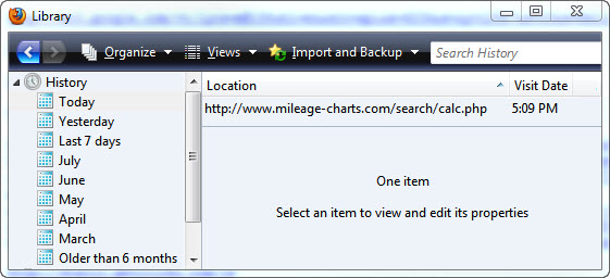
Figure 1: Browser History Entries for Mileage-Charts Visit
vs.
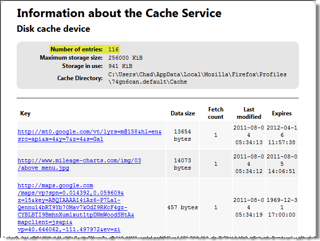
Figure 2: Browser Cache Statistics from Mileage-Charts Visit
Tip: When profiling sites on a test system you might also consider employing a web proxy, like Paros. A web proxy can capture all inbound and outbound web traffic and give the most complete view of dynamic browser activity, including connections that do not result in cached data.
How did I know that the "vp=" parameter contained geo-located coordinates? The answer rests with understanding how web-based mapping services work. A vast number of websites utilize mapping services from Google, Yahoo & Microsoft for visually displaying locations. HTML5 geo-location features allow further customization of these maps and sites are increasingly using them to identify visitor locations. Instead of a hamburger franchise showing all of its locations on a map, it can first determine the visitor's location and show only the closest locations. Only a few lines of code are required to make this change; hence we should expect to see an increasing number of geo-artifacts during our examinations. If we can find the coordinates used by the site to create its map, then that information can be used to tie that device to a location at a specific time, with some degree of accuracy. The easiest place to identify these coordinates is as URL parameters recorded by the browser cache.
Google Maps is the most widely used mapping service so we will use it to demonstrate the analysis process. Similar to reviewing search URLs to identify what a user was searching for, we can identify requests to Google Maps which include location information. This location information is often passed via query string parameters, which are dutifully recorded by the browser cache. As an example, you might find the following:
<blockquote><p><a href="<a href=" http:="" maps.google.com"="">http://maps.google.com</a>/maps?ll=40.760779%2C-111.891047</p></blockquote>
<p>Query" class="redactor-autoparser-object"><a href="http://maps.google.com">http://maps.google.com</a>/maps?ll...
</p>
string parameters for this request are denoted after the question mark. In this case, we see the parameter "ll" used to request a map centered on latitude 40.760779 and longitude -111.891047. Google Maps accepts a multitude of parameters, but Figure 3 contains those I have found most useful to identify device location (green checks are particularly useful).
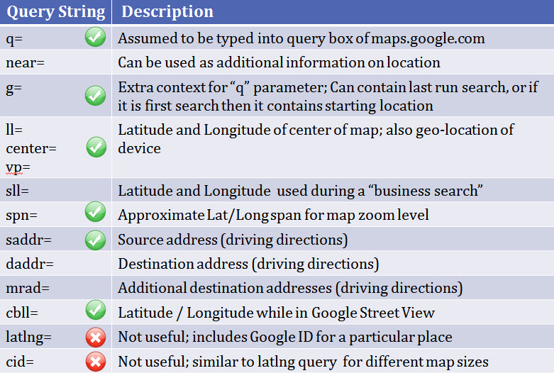
Figure 3: Google Maps API Parameters
In an ideal world, we would be able to determine the device location via the initial communication with the geo-location service. In practice, little of this is stored on the host system because it is conducted via the HTTPS protocol, which explicitly does not cache data. Thus we are required to analyze the by-product of the geo-location, which are the changes made to the page as a result of the new location information (such as a new map being drawn). The difficult part of this process is determining what requests give information about device location. Consider finding an entry for a Google Maps request using a specific set of coordinates. How can we determine definitively if those coordinates are a result of the device being geo-located? In general, we can use the presence of coordinates within URL parameters as an indication of possible geo-location and then test our hypothesis by gathering additional data. Context is extremely important when attempting to identify geo-location artifacts from cached map requests. A search of an address at http://maps.google.com looks much different than a geo-location event triggered by http://twitter.com. A few heuristics:
Putting these into practice with the Mileage-Charts.com example, a review of the browser cache in Figure 2 identified what appeared to be coordinates in maps.google.com URL parameters (vp=40.646062, -111.497972). I cross-referenced the "vp=" parameter with what I know about Google Maps API Query Strings (Figure 3) and identified it as commonly used to center a map. I reviewed other requests during the same browser session (using time stamps) and did not find anything indicating a location search (another maps.google.com entry with a "q=" parameter would lead me to believe a search occurred instead of proper geo-location). Finally, I profiled the site Mileage-Charts.com on a test system to determine if it contained geo-location capabilities and what artifacts I should expect to find.WARNING: URL Parameters are Only One Way to Transmit Geo-location Data
There are multiple ways to interact with Google Maps, and while popular, using query string parameters is only one method. Maps requested via JavaScript or Flash are more likely to embed parameters like coordinates within data files and HTTP Post requests leaving few references to geo-artifacts within the browser cache. Artifacts generated via these methods may still be found in memory or unallocated space via keyword searches. For example, "google.maps.LatLng" is an excellent keyword to identify requests made using the Google Maps JavaScript API.
Next up in part 3: Profiling location-aware web applications
Chad Tilbury, GCFA, has spent over twelve years conducting computer crime investigations ranging from hacking to espionage to multi-million dollar fraud cases. He teaches FOR500 Windows Forensics and FOR508 Advanced Computer Forensic Analysis and Incident Response for the SANS Institute. Find him on Twitter @chadtilbury or at http://forensicmethods.com.